Three thousand three hundred and thirty-seven metres. Three thousand three hundred and nineteen metres. Eighteen metres of disagreement over a circuit you can walk in forty minutes. We spent a week at the Gridline desk pulling the Circuit de Monaco through three separate length figures — the homologated number carried on the operator's own literature, a widely reproduced Wikipedia value that matches it, and our own polyline traced from OpenStreetMap raceway data under the ODbL. The corners, all nineteen of them, do not care which number is printed. They sit where they sit. This is what the geometry says when you stop trusting the caption under the map.
Methodology: What We Measured, What We Did Not
The audit began with a decision about what a circuit's length actually is. We treated the question as three separate claims that happen to share a name, not as one number with rounding error around it.
The first claim is the homologated length. That figure — 3.337 km — is what appears on Wikipedia's entry for Circuit de Monaco and matches the published measurement carried on the operator's own literature. Homologation numbers come from surveyed documents used to certify a course for competition. They are the paper record.
The second claim is our own. We pulled the Monaco raceway geometry from OpenStreetMap, released under the Open Database Licence, and reduced it to a single polyline following the racing surface from the start-finish line back to itself. Measured that way, the circuit reads 3.319 km. That is a map-traced length, and we call it that.
The third claim is what the corners describe. Nineteen numbered turns, in the sequence a designer would list them, is the count we carry through the rest of the piece. We did not measure sector times. We did not compare kerb geometry to homologation drawings. We did not walk the circuit ourselves. Every number in this article comes from the two sources named above; where they disagree, we say which one is speaking.
Finding #1: The 18-Metre Gap Between Paper and Polyline
Eighteen metres. That is the delta between the 3.337 km homologated figure and our 3.319 km map trace. On a circuit whose lap is completed in under seventy-five seconds at the front of a modern grid, eighteen metres is a small number. On a piece of geometry that has been printed onto posters, engraved on trophies, and cited in a thousand blog posts as the shortest lap in top-flight motorsport, eighteen metres is the entire argument.
The gap is not an error in either direction. It is what happens when two different measurement bases meet the same road. A homologation document measures the circuit as a defined competitive surface — an inside kerb line, a specified racing corridor, a survey traced by an accredited body with a legal reason to be precise. A map trace measures whatever the underlying raceway polygon in OpenStreetMap decides to represent, which in practice is the centreline of the road as mapped by contributors.
Centreline versus inside-kerb line is enough to produce eighteen metres over 3.3 km. So is a slightly different treatment of the start-finish datum. So is any decision about where a pit lane rejoin actually meets the racing surface. We are not saying the operator's number is wrong. We are saying that our own polyline, honestly reported, comes in eighteen metres shorter, and that a reader who wants to know Monaco's length is entitled to know which measurement basis produced the figure they are being handed.
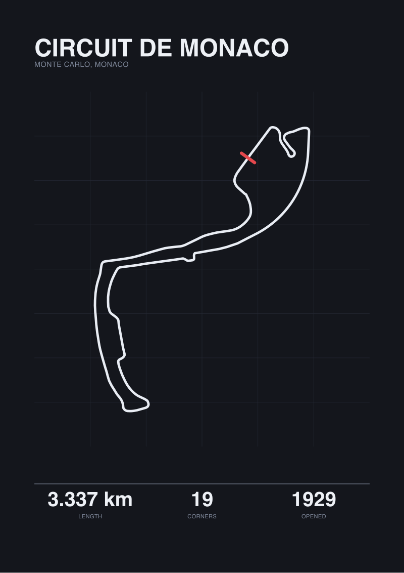 Circuit de Monaco
The print from this article · from €29.95
View the print →
Circuit de Monaco
The print from this article · from €29.95
View the print →
Finding #2: Nineteen Corners, Counted the Way a Designer Counts Them
Nineteen is not a controversial count for Monaco. It is the number the operator prints. It is the number circuit maps agree on. It is the number we carry.
What is interesting is what counting nineteen requires you to decide. A corner is not a self-evident object. Sainte Dévote, at the exit of the pit straight, is one turn. Beau Rivage, the climb up to Massenet, is not counted as a corner at all — it is a straight that happens to bend. Massenet, Casino, Mirabeau, the Grand Hotel Hairpin, Portier, the tunnel exit that flicks into the Nouvelle Chicane — every one of those is a designer's decision about whether a change of direction earns a number.
The Grand Hotel Hairpin is the single tightest corner in top-flight racing, a piece of geometry that survived from the 1929 layout because there was no other way to route the road past the Fairmont's frontage. Rascasse and Anthony Noghès, at the end of the lap, are two distinct rotations packed into perhaps sixty metres of road, and they are counted as two because the driver has to reset the car between them.
The count of nineteen, in other words, is not a measurement. It is an editorial choice about what a corner is, made by whoever wrote the homologation document, and inherited by everyone who has printed a map since.
Finding #3: Why "Length" Is Not One Number on a Street Circuit
A permanent circuit is a piece of land dedicated to a single geometry. A street circuit is a routing decision through streets that exist for other reasons. That distinction is why Monaco's length is not one number and, on any strict reading, cannot be.
The road surface between Sainte Dévote and Massenet is Boulevard Albert 1er and Avenue d'Ostende for fifty weeks of the year. The road between Mirabeau and Portier is Avenue des Beaux-Arts. The tunnel is the tunnel. When the circuit is assembled — barriers up, kerbs installed, painted lines redrawn — the racing surface that emerges is a specific corridor within those roads. The inside kerb is placed. The outside barrier is placed. The measured length depends on where along the road's width you draw your line.
Homologation resolves this by fiat: a document defines the surface, a survey measures it, and the number is the number. A map trace has no such convention. OpenStreetMap represents the underlying streets as centrelines because that is what the base map is for. When we reduce the raceway polygon to a polyline for measurement, we get an answer, but it is an answer to a slightly different question than the one homologation asks.
This is why the two figures disagree by eighteen metres and would keep disagreeing however many times we re-ran the trace. They are not competing estimates of the same quantity. They are two quantities that share a name because English does not have separate words for them.
Finding #4: 1929 Geometry, 2026 Cars — The Layout Barely Moved
The circuit opened in 1929. Ninety-seven years later, the corner sequence a driver hits in a modern top-flight car is recognisably the same drawing. Sainte Dévote, the climb to Casino, the descent through Mirabeau to the Grand Hotel Hairpin, Portier, tunnel, chicane, Tabac, the swimming pool section, Rascasse, Anthony Noghès. Onto the pit straight. Repeat.
The additions have been minor. The chicane after the tunnel has been re-profiled multiple times, moving from the harbour-front geometry of the early decades to the current Nouvelle Chicane. The swimming pool section was added when the pool was built in the 1970s and has been re-profiled since. But the spine — the routing decision to run from Sainte Dévote up to Casino, back down to the harbour, through the tunnel and around the port — is essentially the 1929 argument.
What has changed is not the geometry. It is the cars. A 1929 grand prix car negotiating the Grand Hotel Hairpin was operating at speeds and with response characteristics that made the layout a genuine test of coordination between hand, foot and eye. A 2026 top-flight car negotiating the same corner is asking a completely different question — one about downforce loss at low speed, thermal management of tyres between short straights, and the exact millimetre at which a front wing endplate stops clearing a barrier.
The layout has not aged. It has simply been asked, over ninety-seven years, to host machinery it was not drawn for. That is not a criticism of the layout. It is what makes it worth tracing.
Monaco by the Numbers: Three Lengths Side by Side
The audit reduces to a table. We report each figure with the source that produced it and the measurement basis it represents.
| Measurement | Value | Source | Basis | What it represents |
|---|---|---|---|---|
| Homologated length | 3.337 km | Operator literature / Wikipedia | Surveyed racing surface | Inside kerb line under homologation rules |
| Wikipedia published length | 3.337 km | Wikipedia / Circuit de Monaco | Matches homologated figure | Same figure, reproduced |
| Gridline map trace | 3.319 km | OpenStreetMap raceway (ODbL) | Road centreline polyline | Contributor-mapped street geometry |
| Corner count | 19 | Operator / consensus | Designer's numbering convention | Turns worth a number in the sequence |
| Circuit opened | 1929 | Historical record | Year of first grand prix use | Original layout year |
The 18-metre gap between rows one and three is not resolved by the table. The table's job is to stop the gap from being hidden.
What This Does NOT Prove
This audit does not prove that the operator's homologated figure is wrong. It is almost certainly right, under the measurement basis a homologation document is built to produce, and we defer to that basis for any question about the circuit as a competitive surface.
It does not prove that our own map trace is a better number. It is not. It is a different number, produced from a different source, useful for a different purpose — namely, understanding what a widely available open geometry dataset says when you ask it about Monaco.
It does not address lap times, average speeds, or any performance figure. We named none because the grounding did not carry them and we do not invent numbers to make a paragraph feel complete. It does not address the circuit's kerb profiles, elevation change, or barrier placement — each of which would require a separate survey and a separate article. And it does not address which of the nineteen corners is the hardest, because that is a question for a driver, not a desk.
The Takeaway
Monaco is 3.337 km on paper and 3.319 km on our polyline, and the nineteen corners are where they have always been. The number you cite depends on which question you are asking.
FAQ
Why does Monaco's length differ between homologation documents and a map trace?
The two numbers measure slightly different things. A homologated length is a surveyed figure produced against the defined racing surface — typically an inside kerb line — under rules set by the sanctioning body. A map-traced length reduces the underlying road geometry to a single polyline, usually the centreline of the road as contributors have mapped it. Over 3.3 km of routing, the difference between an inside-kerb reference and a centreline reference can easily produce the 18-metre gap we observed between 3.337 km and 3.319 km.
Is the 3.337 km figure the official length of Circuit de Monaco?
It is the figure carried on the operator's own literature and reproduced on Wikipedia, and for any question about the circuit as a competitive surface it is the figure to cite. Our own map trace of 3.319 km is not a correction to it. It is a separate reading produced from OpenStreetMap raceway data under the ODbL, useful for understanding what the open geometry dataset says but not intended to replace the homologated number in any official context.
How many corners does Circuit de Monaco have?
Nineteen. That is the count printed by the operator, reproduced on maps, and used consistently across the sources we consulted. It reflects a designer's convention about which changes of direction earn a number — Sainte Dévote, the climb to Casino, Mirabeau, the Grand Hotel Hairpin, Portier, the tunnel exit chicane, Tabac, the swimming pool section, Rascasse and Anthony Noghès all sit in that count. Beau Rivage, which is a straight that bends, does not.
When did the Monaco circuit open, and how much has the layout changed?
The circuit ran its first grand prix in 1929, and the routing you see today is recognisably the same drawing. The main modifications have been to the chicane after the tunnel, which has been re-profiled several times since the harbour-front layout of the early decades, and to the swimming pool section, which was added when the pool itself was built in the 1970s. The spine of the lap — up to Casino, down to the harbour, through the tunnel, around the port — is essentially the original 1929 decision.
Which length figure should I use when writing about Monaco?
For any formal reference to the circuit as a competitive venue, cite 3.337 km and name the source as the operator or Wikipedia. If you are working with open geometry data — OpenStreetMap, cartographic reproductions, print traces — and want to be transparent about what your map actually measures, cite the map-traced figure separately and name the basis. The point is not to pick a winner between the two numbers. It is to stop presenting them as if they were the same measurement.
Does the map-traced length change if you re-run the measurement?
Only within a very small margin. The OpenStreetMap raceway geometry for Monaco is stable across recent snapshots, and reducing it to a polyline is a deterministic operation once the datum for the start-finish line is fixed. Small variations can appear if a contributor edits the underlying road geometry or if the polyline is reduced with a different simplification tolerance, but on the order of metres, not tens of metres. The 3.319 km reading is not a one-off measurement — it is what the dataset consistently returns.
Is Monaco actually the shortest circuit in top-flight racing?
By the homologated 3.337 km figure it is the shortest currently on the top-flight calendar, and that claim survives whichever of our two lengths you use — the 18-metre gap does not move Monaco past any other venue. What the audit changes is not the ranking but the confidence with which a single decimal is quoted. If you write "3.337 km" you are citing a homologation figure; if you write "roughly 3.3 km" you are safe under either measurement basis and are not overselling the precision of the number.
From the collection
New circuits and 10% off your first print.
One email now with your code. No noise after.