We have read a lot of articles ranking Europe's best race circuits by layout. They tend to arrive at the same short list — the Nordschleife's 20.832 km and 154 turns, Spa's 7.004 km through the Ardennes, Silverstone's 5.891 km across a former airfield, the 13.626 km public-road loop of the Circuit de la Sarthe — and then order them by feel. The measurements are lifted from the same handful of pages. The word "iconic" appears more than once. What almost never appears is the drawing itself: what the geometry does, why it is that shape, and what the numbers actually measure. That absence is the whole problem.
What Every Ranking of European Circuits Gets Wrong
The first error is treating published length as a settled number. It is not. Every circuit publishes a homologated length that comes from a governing body's certification document; that number exists to satisfy regulations about grid spacing, distance to first corner, and race distance. It is not the length of the driving line, and it is not, in most cases, the length you would get by tracing the centre of the raceway on a map.
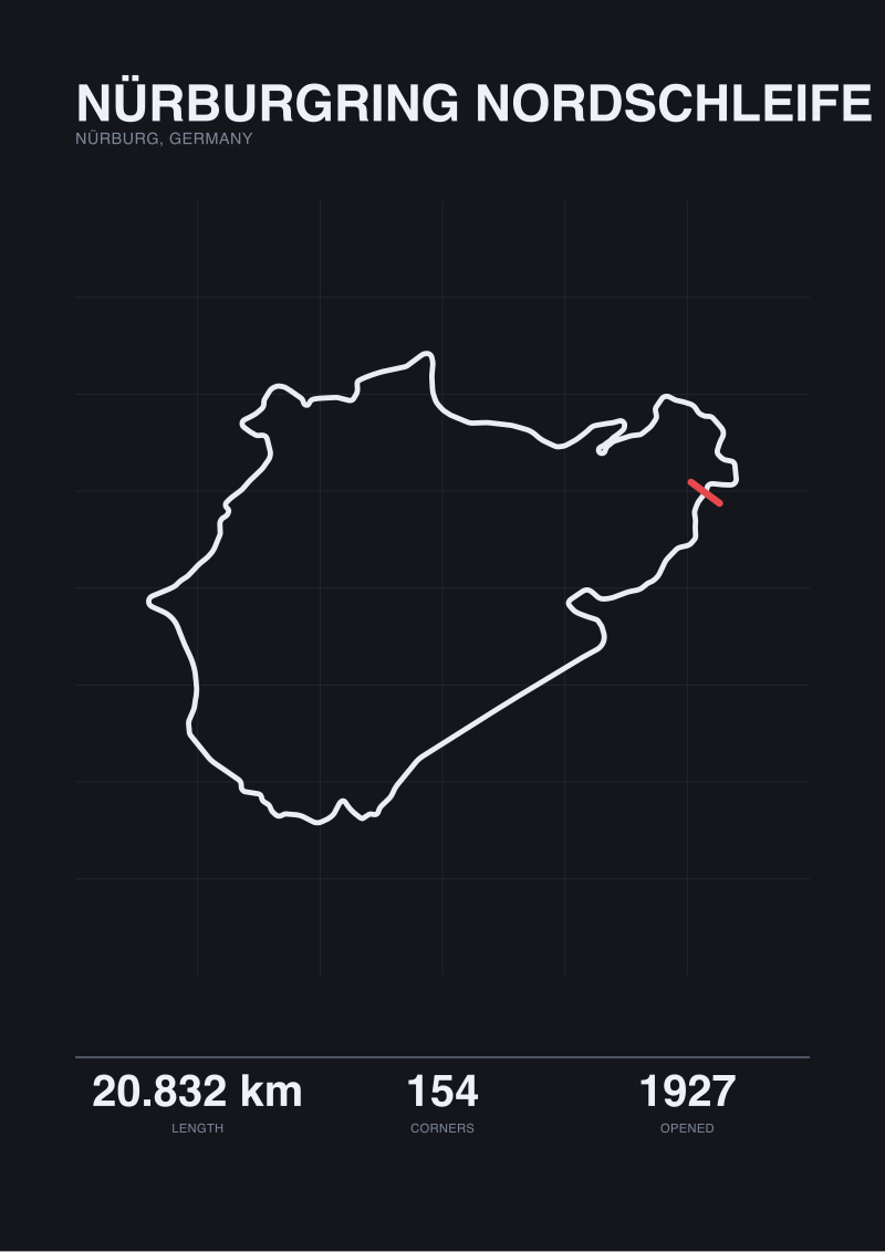
We know this because we do the second thing. When we trace the Nürburgring Nordschleife from OpenStreetMap raceway data, we get 20.746 km. The official published length is 20.832 km. The gap is 86 metres — a rounding error to a spectator, a whole braking zone to a designer. For Spa-Francorchamps, published length is 7.004 km, traced geometry 6.995 km; a 9-metre delta. For Silverstone, 5.891 km published against 5.881 km traced; 10 metres. These are small numbers, but the point is not the size of the gap. The point is that "5.891 km" and "5.881 km" are answering different questions, and a ranking that compares circuits by length without saying which measurement basis it used is comparing apples to a certificate.
The second error is treating turn count as a scalar. The Nordschleife is credited with 154 turns. Spa has 19. Silverstone has 18. Read as raw numbers, the Nordschleife is roughly eight times more complex than Spa. Read as a drawing, that is not what is happening at all. The Nordschleife is 20.832 km of a mountain road catalogued at close resolution; a Wehrseifen, a Brünnchen, a Pflanzgarten each counted as a distinct feature. Spa is a modern permanent circuit where the turn numbering follows FIA convention, so a slight kink on the Kemmel Straight does not get a number, but a comparable radius on the Nordschleife does. Turns per kilometre — 7.4 for the Nordschleife, 2.7 for Spa, 3.1 for Silverstone — tells you more, but only just, because the underlying question is what counts as a turn, and no ranking article we have read defines it.
The third error is the one the format itself commits: it presents a hierarchy without a criterion. "Best by layout" resolves to an ordering, but layout is not one variable. It is a bundle of at least six: length, corner density, elevation range, corner type distribution, sight-line geometry, and racing surface width relative to car width. Rank one circuit above another and you have implicitly weighted those six. The rankings we have read never say which weights they chose. In practice they weight fame.
What Is Almost Always Missing From the Layout Conversation
The first missing thing is provenance. A circuit's layout was designed under a specific set of constraints — cars of the period, roads that already existed, land the promoter could get, safety standards of the decade — and the drawing is a record of those constraints. The Nordschleife opened in 1927, on terrain the designers were reading rather than shaping. Spa-Francorchamps opened in 1921 on a triangle of public roads between Francorchamps, Malmedy, and Stavelot, and its modern permanent configuration is the residue of successive shortenings. Silverstone opened in 1948 on the perimeter tracks and runways of a former RAF airfield in Northamptonshire; its earliest layouts were nearly all right-angles because that is what airfield taxiways are. The Circuit de la Sarthe, with its 13.626 km published length, is still today a hybrid of the permanent Bugatti section and closed public roads that carry ordinary traffic outside the race weekend. A ranking that treats these four as comparable objects is treating a mountain, a valley road, an airfield, and a public highway as if they were four versions of the same drawing.
The second missing thing is elevation. Every one of the circuits above lives partly in the vertical axis, and none of the rankings we have read say anything about it. The Nordschleife rises and falls across the Eifel; Spa's Eau Rouge–Raidillon complex is a vertical event before it is a horizontal one; even Silverstone, notionally flat, has enough camber changes across its former airfield to matter. Length in kilometres is a projected number: it treats the circuit as if it were drawn on a table. The driving line does not live on a table.
The third missing thing is what any of it does to racing. Corner density affects overtaking; long straights terminated by heavy braking zones create passes; blind crests suppress them. Sight-line geometry — where the driver can see, and for how long — is not visible in a top-down map but is present in every conversation drivers have about a track. The rankings we have read do not read the geometry as a set of causes. They read it as a set of names.
The fourth, more quietly missing thing is honest uncertainty about the measurement itself. When we traced the Circuit de la Sarthe from OpenStreetMap raceway data, we recovered only 0.793 km — a fragment, not the loop. The correct response to that is not to invent the remainder. It is to say what we have, and what we do not, and to acknowledge that a public-road configuration is a harder object to trace than a permanent circuit whose full boundary is tagged. Rankings do not admit such limits. They print the certified number and move on.
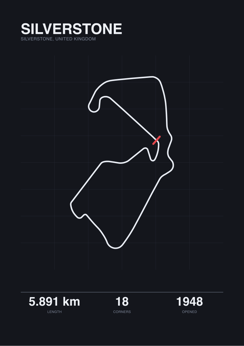 Silverstone
The print from this article · from €29.95
View the print →
Silverstone
The print from this article · from €29.95
View the print →
What We Would Say Instead: Reading Four Circuits as Drawings
Replace the ranking with a reading. Take the four circuits the field keeps returning to and treat each as a document written under specific constraints.
The Nordschleife, in Nürburg, Germany, is 20.746 km on our trace and 20.832 km on paper, and either number is a summary of a decision the 1927 designers made not to fight the mountain. The road climbs the Eifel and descends it. Its 154 catalogued turns are not 154 discrete engineering choices; they are the resolution at which the drawing has been indexed, because at 20.832 km a coarser index would lose the shape. The circuit's layout does not follow from a track designer's aesthetic. It follows from topography. That is why nothing built afterwards feels like it, and why comparisons treating it as an unusually long permanent circuit miss what it actually is: a road catalogue.
Spa-Francorchamps, in Stavelot, Belgium, is 6.995 km traced, 7.004 km published, 19 turns, opened 1921. The drawing is the shortened descendant of a much longer public-road triangle; the modern permanent circuit inherits the valley the original roads used, which is why its most-discussed section — the Raidillon complex — is a vertical geometry rather than a planar one. At 2.7 turns per kilometre, Spa is one of the least corner-dense circuits in this set, and the low density is inseparable from the fact that the original constraint was existing road, not a track designer's blank sheet.
Silverstone, in Silverstone, United Kingdom, is 5.881 km traced, 5.891 km published, 18 turns, opened 1948. It is the youngest of the four and the one whose drawing owes least to landscape. A former RAF airfield is close to a blank sheet: the runways and perimeter roads gave the earliest configurations their nearly-right-angle character, and every subsequent redraw has been the work of designers negotiating with a mostly flat, mostly rectangular parcel. At 3.1 turns per kilometre, Silverstone is corner-denser than Spa but sparser than the Nordschleife, and the shape is the shape of an engineered compromise rather than a road that already existed.
The Circuit de la Sarthe, with a published length of 13.626 km, is the case where the honest thing to say is what we do not know. Our own map trace over OpenStreetMap raceway data returned 0.793 km. That is not the loop. It is the fragment the tagging covered. The circuit is a hybrid of permanent facility and closed public roads, and its layout is best understood as a road-based configuration whose full boundary is not consistently mapped in the same way a permanent circuit is. To rank it against Silverstone on length is to compare a certificate with a trace and pretend they are the same number.
What emerges from reading these four as drawings rather than as ranks is that "best layout" is not a leaderboard question. It is a genre question. A mountain road, a valley shortened out of a triangle, an airfield with corners added, and a highway loop closed for one weekend a year belong to four different genres of circuit design, and the reason ranking them feels unsatisfying is that the exercise is category-confused before the first entry is placed. What we would say instead is: measure what you are measuring, name it, and let the drawing do the argument.
FAQ
Why do published circuit lengths differ from map-traced measurements?
Published lengths come from homologation documents issued by governing bodies and exist for regulatory purposes: grid spacing, race distance, minimum straight lengths. Map-traced measurements are geometric readings of the raceway centre-line from open geospatial data. The two answer different questions. For the four circuits in this piece, the gaps run from 9 metres at Spa to 86 metres at the Nürburgring Nordschleife — small in absolute terms, but a reminder that "length" is not a single number.
How is the Nürburgring Nordschleife's 154-turn count actually derived?
The 154 figure is a catalogued index of named features across the 20.832 km circuit, at a resolution fine enough to distinguish sections like Wehrseifen, Brünnchen, and Pflanzgarten. It is not directly comparable to the 18 turns of Silverstone or 19 of Spa, which follow modern FIA numbering conventions that treat many small radius changes as part of a single sequence. Turns per kilometre — roughly 7.4 for the Nordschleife against 2.7 for Spa — is closer to like-for-like, but even that depends on what counts as a turn.
What makes the Circuit de la Sarthe difficult to measure from map data?
The Circuit de la Sarthe is a hybrid: part permanent facility, part closed public road that carries ordinary traffic outside the race weekend. That makes its OpenStreetMap raceway tagging incomplete relative to a purpose-built circuit. Our own map trace recovered only 0.793 km, which is a fragment rather than the 13.626 km published loop. The honest reading is that public-road configurations are harder objects to trace consistently, and that the certified length remains the reference figure.
Why does the piece avoid ranking Spa, Silverstone, and the Nordschleife against each other?
Because they are different genres of circuit. The Nordschleife (opened 1927) is a road catalogue laid over Eifel terrain. Spa-Francorchamps (opened 1921) is the shortened descendant of a public-road triangle in the Ardennes valley. Silverstone (opened 1948) is an engineered layout on the perimeter of a former RAF airfield. Ranking them on "layout" collapses those distinct origins into one criterion — usually fame — and hides the design constraints that produced each drawing.
What information about a circuit's layout is usually left out of "best of" pieces?
Provenance, elevation, and sight-lines. Provenance is the set of constraints — cars of the period, existing roads, available land, safety standards — under which the drawing was made. Elevation is the vertical axis a top-down map suppresses; Eau Rouge–Raidillon at Spa is a vertical event before it is a horizontal one. Sight-lines determine what the driver can see and for how long, which shapes overtaking geometry in a way that no plan-view length or turn count captures.
What is a more useful way to compare circuit layouts than a ranking?
Read each circuit as a drawing produced under specific constraints and describe what the geometry does. That means naming the measurement basis (homologated length or traced length), stating turn density with a defined counting convention, noting elevation where it dominates the layout, and identifying the design genre — road-based, terrain-following, or engineered-on-a-blank-sheet. The output is not an ordering. It is a set of comparable readings that let the reader form their own view.
What are the four circuits in this piece and their key measured figures?
The Nürburgring Nordschleife, in Nürburg, Germany: 20.832 km published, 20.746 km map-traced, 154 turns, opened 1927. Circuit de Spa-Francorchamps, in Stavelot, Belgium: 7.004 km published, 6.995 km map-traced, 19 turns, opened 1921. Silverstone Circuit, in Silverstone, United Kingdom: 5.891 km published, 5.881 km map-traced, 18 turns, opened 1948. Circuit de la Sarthe: 13.626 km published; map-traced measurement incomplete at 0.793 km owing to the circuit's public-road character.
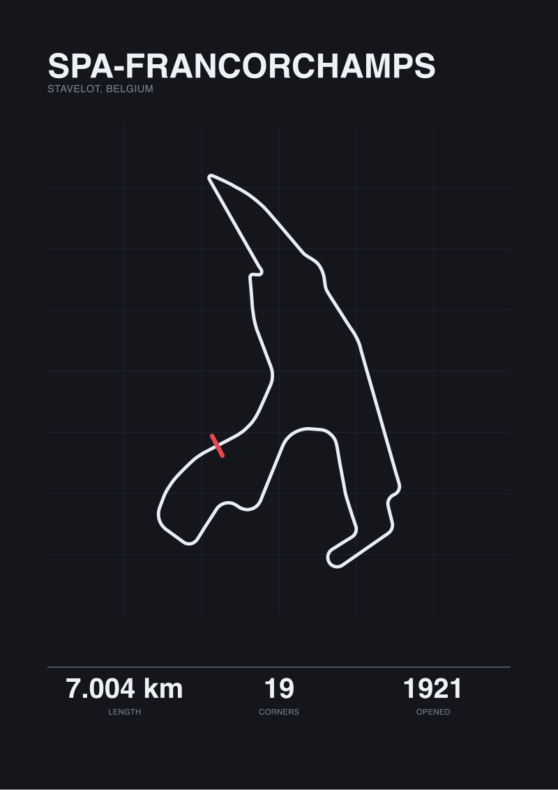 Spa-Francorchamps
The print from this article · from €29.95
View the print →
Spa-Francorchamps
The print from this article · from €29.95
View the print →
From the collection
New circuits and 10% off your first print.
One email now with your code. No noise after.