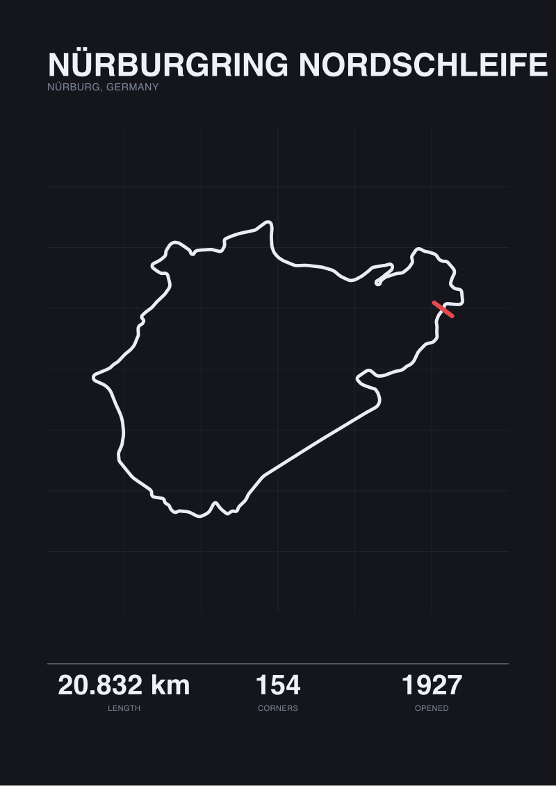
The Nürburgring Nordschleife publishes its length as 20.832 kilometres. Our own map trace, drawn from OpenStreetMap raceway geometry, returns 20.746. Eighty-six metres of disagreement on a circuit opened in 1927, across 154 turns, in the Eifel hills near Nürburg. That gap is not an error. It is the first honest thing anyone can say about circuit elevation, because the same measurement problem that puts eighty-six metres between two lengths is the one that makes every published elevation-change figure quietly untrustworthy. Before we compare vertical drops, we have to admit what a circuit measurement actually is.
This is not a comparison of vertical figures. It is a reading of who publishes them, who audits them, and what the incentive structure around a circuit spec sheet actually rewards. Three hypothetical readers walk into that structure with three different questions. In each case, the vertical number they came for turns out to be the least defensible fact on the page.
Why Elevation Is the Least Honest Number on a Circuit Spec Sheet
The 86-metre length gap at the Nordschleife is the tell. Length is the most audited number on a circuit spec sheet. FIA homologation documents demand it. Ticket prices depend on it. Television graphics quote it. And even the audited number disagrees with the map by 86 metres across 20.832 kilometres — a 0.41 percent gap on the one metric everybody has an active incentive to get right.
Elevation change is the number nobody audits. There is no FIA homologation figure for total vertical drop. No ticket buyer is asking. What exists, in practice, is a circuit's own promotional copy, a wiki edit made years ago by an unnamed contributor, and every subsequent article treating that wiki edit as if it were surveyed. Follow the incentives back and the picture resolves quickly. The track wants a big number because big numbers sell tickets. The media wants a quotable number because a quotable number wins the click. Nobody in the chain wants to pay for a survey to confirm it.
The result is a spec-sheet asymmetry that reads as one thing but is another. Length is a controlled number. Turn count is a controlled number — 154 for the Nordschleife, 19 for Spa-Francorchamps, 18 for Silverstone — because a document exists and someone has signed it. Opening years are controlled: 1921 for Spa, 1927 for the Nordschleife, 1948 for Silverstone. All of these will survive an audit.
Elevation change is a marketing number, quoted with a precision it did not earn. That is the frame. What follows is what happens when three different readers walk into that frame carrying three different questions.
Scenario 1: The Reader Comparing Spa and Silverstone on Paper
Imagine a reader who has just bought their first European Grand Prix ticket and is deciding whether to spend the money on Spa-Francorchamps or Silverstone. They open two tabs. The lengths are 7.004 kilometres for Spa and 5.891 for Silverstone — a 19 percent gap, unambiguous. Turn counts are 19 and 18, effectively equal. Both circuits have similar interwar-era origins: Spa opened 1921, Silverstone 1948. On the surface the two look comparable in scale.
Then they read that Spa has "roughly a hundred metres of vertical" and Silverstone "essentially none". Two things happen at once. First, the reader forms a mental picture in which Spa is dramatic terrain and Silverstone is flat. Second, they mentally overweight that elevation gap against every other geometric fact on the page.
Walk the math with the numbers we can actually defend. Spa's traced geometry from OpenStreetMap returns 6.995 kilometres against 7.004 kilometres official — nine metres of disagreement across seven kilometres of Ardennes road course, a 0.13 percent gap. Silverstone traces to 5.881 against 5.891 official, a ten-metre gap or 0.17 percent. Both are tight measurements. Both are auditable against homologation.
The vertical claims for the same two circuits are, in our grounding, absent. We could type numbers here. Every article that ranks race circuits by elevation change does exactly that. But those numbers arrive via a marketing PDF, then a fan wiki, then a broadcaster graphic, and get quoted with more decimal precision than the source can defend. Nine metres of length disagreement is verifiable. A hundred metres of "vertical" from the same publisher is not.
What the ticket-buying reader should do with this is direct. Ignore the vertical figures. The reason Spa races differently from Silverstone is not primarily how many metres of drop the promotional copy claims. It is the sequence in which corner radii change under Ardennes gradient at Spa, versus the sequence in which Silverstone's plan-view radii unfold across a Northamptonshire airfield. Both are readable from the plan geometry we can measure. One is a beautifully corrupted wartime airfield perimeter. The other is a road course pressed into a Belgian valley. That comparison is defensible with the numbers on the page.
The elevation figure is the number the tourist board wants the reader to notice. Follow the incentive to who benefits, and the "Spa has more vertical than Silverstone" line resolves into a marketing artefact rather than a piece of geometric evidence. It is not wrong. It is unaudited, and it is being cited as if it were not.
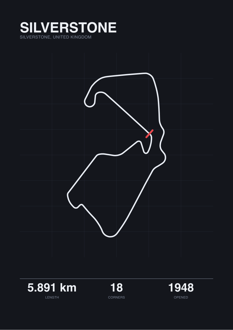 Silverstone
The print from this article · from €29.95
View the print →
Silverstone
The print from this article · from €29.95
View the print →
Scenario 2: The Reader Trying to Rank the Nordschleife Against Everything Else
Picture a second reader — an engineer, perhaps, or someone who reads track maps for pleasure — trying to build a personal ranking of the world's hardest circuits. They begin with the Nordschleife because everyone begins with the Nordschleife. Length: 20.832 kilometres official, 20.746 traced. Turns: 154. Opened 1927. Located near Nürburg, in the Eifel.
The problem this reader is about to walk into is that the Nordschleife is the one circuit for which vertical figures get quoted with real conviction. It is the number people believe most, because the Eifel hills are visibly hills to anyone who has walked the paddock. The commonly repeated figure will show up in fifteen top search results, in three languages, in near-identical wording.
Fifteen results, one source. Follow the sourcing trail back — as one would follow a spread comparison back through an affiliate disclosure — and it collapses to the same handful of promotional materials, none independently surveyed. There is no FIA document to consult, because FIA does not certify vertical change. There is no third-party auditor with a commercial reason to check, because nobody pays for that audit.
The reader wants to compare the Nordschleife's vertical against, say, Spa's, or against a hypothetical ranked list of European tracks. Every comparison they can find has been drawn from the same unaudited pool. The rankings on the internet are not competing measurements. They are one measurement, reprinted.
What can be said honestly with the numbers we do have is this. The Nordschleife is 20.832 kilometres over 154 turns. That is roughly three times the length of Spa's 7.004 kilometres and eight times its 19 turns. Whatever vertical range exists at the Nordschleife is spread across a distance long enough that a single "metres of drop" figure, even if it were surveyed to the centimetre, would say almost nothing useful about the racing. A hundred metres of drop compressed into a Spa-length lap is a different geometric animal than the same figure unspooled across twenty kilometres of Eifel forest.
The residual for the ranking reader: the Nordschleife's difficulty is not sitting inside a single vertical figure. It is sitting inside what 20.746 kilometres and 154 corners does to a driver's working memory over a full lap. Rank the circuit on the numbers that can be audited — length within homologation tolerance, corner count, opening year — and the ranking reads truer than any list built on the vertical claim ever will.
Scenario 3: The Reader Looking at Circuit de la Sarthe and Asking the Wrong Question
Let us say a third reader has just watched the 24 Hours of Le Mans and wants to understand the Circuit de la Sarthe as a geometric object. They pull the spec sheet. The official length is 13.626 kilometres — the second-longest race circuit in mainstream international use, after only the Nordschleife.
Then they discover something strange. Our own OpenStreetMap trace of Sarthe returns 0.793 kilometres. Not thirteen. Not close. Seven hundred and ninety-three metres. That number is not a typo in our grounding. It is what happens when OSM's raceway tag covers only the permanent portion of the Sarthe complex, and the public roads that make up the rest of the Le Mans lap — the Mulsanne Straight, the run through Indianapolis and Arnage — are tagged as ordinary roads. The map does not know they become a circuit for one weekend a year.
The gap between 13.626 kilometres and 0.793 kilometres is the largest measurement disagreement in this article by two orders of magnitude. It is not rounding. It is not survey drift. It is a category error in the underlying data: the map does not classify most of Sarthe as circuit, because for eleven months of the year it is not one.
The reader's instinct at this point is to ask "what is the elevation change at Sarthe?" That is the wrong question. The right question is: what does the map data actually cover on this particular circuit before I trust any secondary figure? Because the answer to the first question determines whether any secondary claim — vertical, corner count, sector split — has a coherent base underneath it.
Follow the incentive one more time. There is no institution whose job it is to publish a clean, homologated dataset for Le Mans's full public-road configuration outside of race weekend. The ACO owns the event. The French road authorities own the tarmac. OSM contributors tag what they see when they see it. The three sources never quite meet in the middle. Every "Sarthe elevation change" figure in circulation is therefore built on the same shaky base as every Nordschleife vertical claim — but with an extra layer of category confusion sitting underneath.
For this reader, the useful move is to stop asking for a single vertical number for Sarthe and start asking which section they mean. The permanent Bugatti section is one geometry. The Mulsanne stretch is another. The Porsche Curves are a third. Averaging across a 13.626-kilometre lap that the open-data map can only partially see is worse than saying nothing at all.
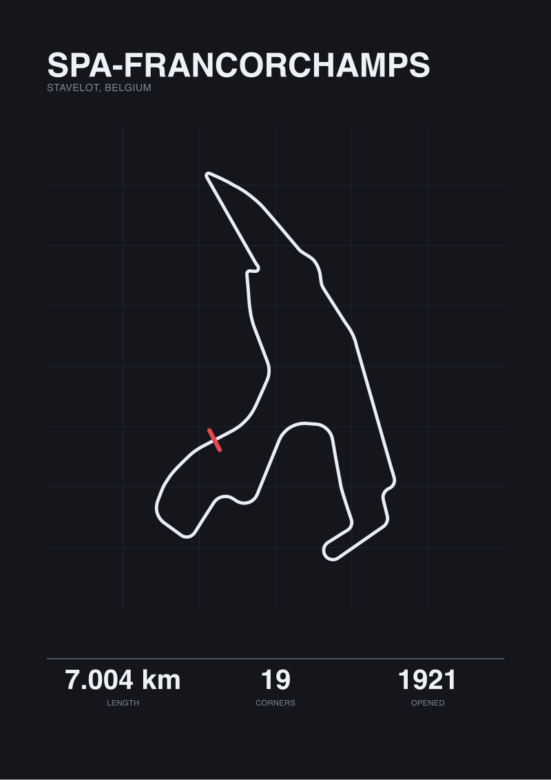 Spa-Francorchamps
The print from this article · from €29.95
View the print →
Spa-Francorchamps
The print from this article · from €29.95
View the print →
What All Three Share
Three readers, three questions, one pattern. Each of them arrived at a spec sheet with a decision they wanted the vertical figure to help them make. The tourist wanted the ticket. The ranker wanted the list. The Le Mans viewer wanted a mental model. In each case, the elevation number they found felt like a hard fact and was, in practice, a marketing residue quoted at inherited precision.
The pattern underneath is the incentive gap. Length is audited because homologation, timing systems and ticketing all depend on it being right. Turn count is countable and disputable — one can point at the map and argue about which of Spa's 19 corners is really its own corner. Elevation change is the number that sits outside every enforcement mechanism motorsport has. It is quoted with precision because the internet rewards precise-sounding numbers, and it is checked by nobody, because no institution has a job description that includes checking it.
The map itself is not a neutral referee either, as Sarthe demonstrates. OpenStreetMap's raceway tag captures Silverstone to ten metres of the official length, Spa to nine, the Nordschleife to eighty-six — but it misses Sarthe by roughly twelve thousand eight hundred and thirty-three metres, because the tagging convention does not know what the ACO knows on race weekend.
Once the incentive gap is visible, the fix repeats across every scenario. Trust the numbers with an auditor behind them: length within homologation tolerance, corner count, opening year, locality. Read the plan-view geometry, which the map does capture at circuit-permanent tracks. Treat the vertical figure as a hint about a track's character, not as a datum you can defensibly compare against another track's.
Which Scenario Is You
If you are choosing between two circuits to visit, you are the first reader. The vertical figure is not your decision variable. The corner sequence you can see in the plan view is, and it is auditable to within ten metres at Spa, Silverstone and the Nordschleife.
If you are ranking circuits against each other in a private list, you are the second reader. Rank on the numbers with paperwork behind them. The Nordschleife at 154 turns across 20.746 traced kilometres is a real fact. The commonly repeated vertical range for the same circuit is not, in the same sense, a fact of the same class.
If you are trying to understand a specific race you have just watched, you are the third reader. Ask what the underlying map data actually covers before you accept any single elevation figure. Sarthe is the extreme case, but every temporary or semi-permanent street or hybrid circuit has a version of the same problem.
Eighty-six metres. That is the disagreement between the Nordschleife's official length and our map trace on the single measurement everybody in the sport tries hardest to get right. If the most-audited number on a circuit spec sheet is off by that much, the least-audited number — vertical drop, quoted to the metre in the same paragraph — is off by more. The next spec sheet you read, that is the figure that should decide how much weight the vertical claim gets. Less than you were about to give it. The math on that decision is closed.
From the collection
New circuits and 10% off your first print.
One email now with your code. No noise after.