Monaco's layout is not preserved. It is constrained. Hear me out. The Circuit de Monaco has run essentially the same 3.337 km of Monte Carlo streets since 1929 — nineteen corners folded around a harbour and a hill — and the standard reading of that permanence is romantic: heritage, tradition, a track that refuses to modernise. Our own trace of the raceway from OpenStreetMap data returns 3.319 km, eighteen metres shorter than the homologated figure, and points to a duller explanation. The layout does not change because the city will not move for it. This article is a flowchart. We will ask you three questions to work out which version of that answer you actually need.
Question 1: Are You Asking About the Track, or About the City?
This is the first fork because most explanations of Monaco's permanence answer the wrong question. People ask "why doesn't the circuit change" as if there is a circuit sitting in a paddock somewhere that a designer could redraw. There is not. What exists in Monte Carlo is a road network, and one week a year the road network is closed and named a circuit. The 3.337 km is a subset of the principality's public streets. The nineteen turns are junctions, harbour walls, and the exits of tunnels that people commute through the other fifty-one weeks. That matters because it decides what "changing the layout" would even mean.
If Yes — you are asking about the track
Then the honest answer is that there is not much track to talk about. Every metre of the 3.337 km is a load-bearing piece of Monte Carlo infrastructure: the Boulevard Albert I along the harbour front, the climb up Beau Rivage past the Casino, the tunnel that carries traffic under the Fairmont hotel. A permanent circuit designer moves earth. A street circuit designer negotiates with a mayor. The two jobs are not comparable, and the reason Monaco's shape has held since 1929 is closer to a property registry than to a design philosophy. Read this as a question about civic geography, not motorsport engineering, and the permanence stops looking mysterious.
If No — you are asking about the city
Then the constraint is the answer. Monaco is 2.08 square kilometres of sovereign land pinned between the Mediterranean and the French Alps, and every square metre already carries a use: apartment, hotel, marina berth, road. There is no adjacent land to expand into and no interior land to reclaim without demolishing something older than the race. The 3.337 km circuit is essentially the longest continuous loop of public road the principality can spare for a weekend. If you want the layout to change, you have to first produce new streets, and new streets in Monaco arrive at roughly the pace of new districts — decades, not seasons. Fontvieille, the reclaimed harbour on the west side, is the last piece of land the principality added, and its geometry did not integrate into the race loop.
Question 2: Do You Trust the Published 3.337 km Figure, or the Map?
The second fork is a measurement problem, and it matters because a great deal of confident writing about Monaco assumes a level of precision the data does not support. Wikipedia and the circuit's own communications give the length as 3.337 km. Our trace of the OpenStreetMap raceway polyline returns 3.319 km. That is a gap of eighteen metres — small in absolute terms, but not zero, and it is worth understanding what it means before you use either number in an argument.
If Yes — you trust the 3.337 km figure
Then you are trusting a homologated measurement: the length agreed on between the circuit and the sanctioning body, using the racing line convention that governs sport regulations. Homologated lengths are not casual estimates. They are measured to a defined path — typically a metre from a specified kerb edge — and they are the number that lap records are calculated against. If you are writing about lap times, average speeds, or pit stop windows, this is the correct figure to use, and it is the one every historical record for the event is expressed in. The eighteen-metre discrepancy with our trace is not evidence the official figure is wrong; it is evidence that "the length of a track" is a definition, not a fact, and the definition here is the sport's.
If No — you trust the map
Then you are trusting a geometric measurement of the road centreline, drawn from open-source cartography under the OpenStreetMap ODbL licence. This is the number a designer uses when they are trying to understand shape rather than performance: how the curvature distributes, where the straights actually sit, how much of the loop is climb versus descent. Our 3.319 km comes from that centreline, and it will always run slightly shorter than a homologated figure because the racing line hugs different geometry than the centre of the road. Neither number is a lie. They answer different questions, and when we discuss Monaco's geometry in this piece we use the traced figure; when we discuss the sport, we use the homologated one. It is the same discipline that separates a survey from a spec sheet.
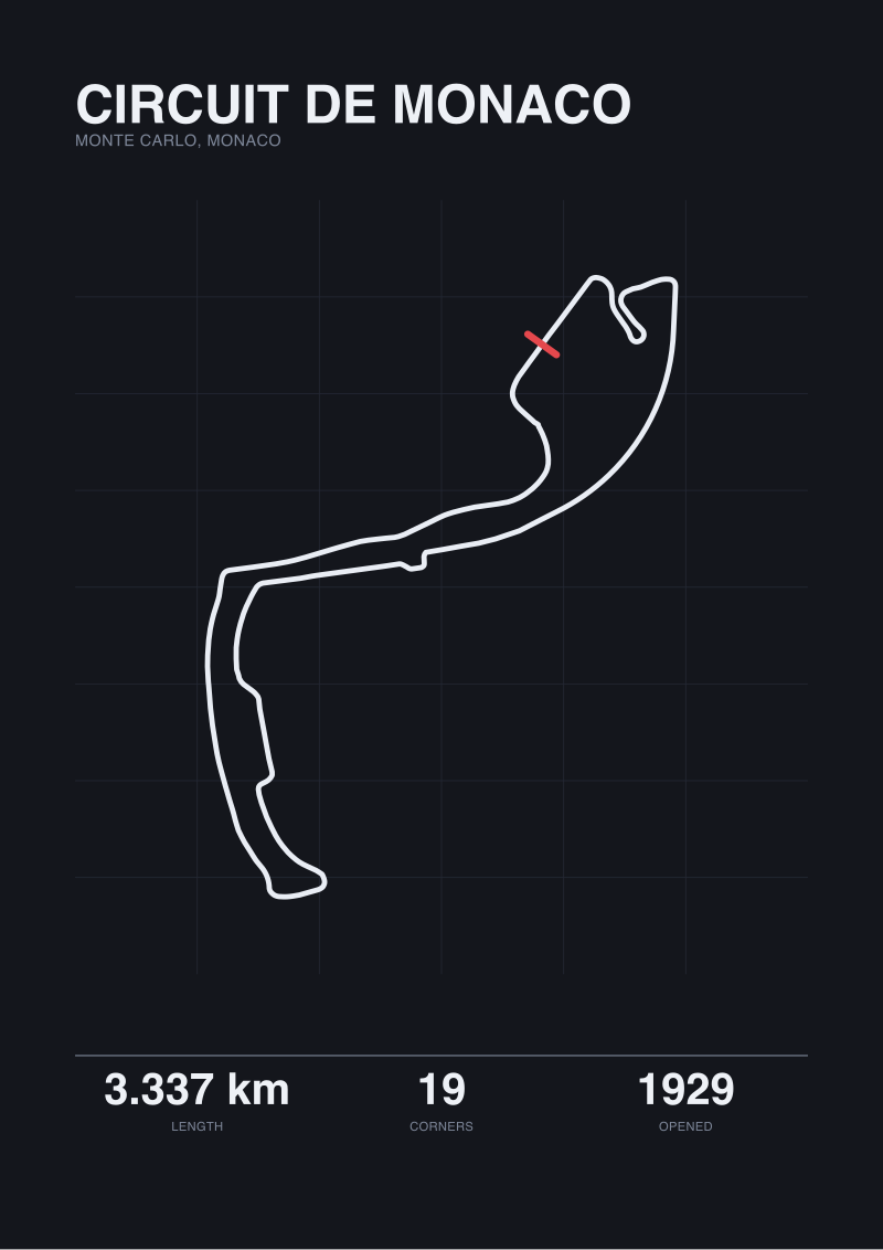 Circuit de Monaco
The print from this article · from €29.95
View the print →
Circuit de Monaco
The print from this article · from €29.95
View the print →
Question 3: Are You Watching Monaco for the Layout, or for the Racing?
The third fork is the one most conversations about Monaco stall on, and it decides whether the layout's permanence is a virtue or a problem. Because the same 3.337 km that carried cars in 1929 now carries cars whose dimensions, aerodynamic footprint, and tyre widths were unimaginable when the streets were laid out. The circuit did not evolve with the machinery. That is either the point or the failure, depending on why you are watching.
If Yes — you are watching for the layout
Then Monaco is one of the most legible circuits in the world, and its resistance to modernisation is precisely what makes it readable. Nineteen corners in 3.337 km is a corner every 176 metres on average, and there is no meaningful straight in the traditional sense — the longest segment between direction changes is short enough that a modern car spends almost the entire lap either turning, braking, or accelerating out of a turn. A designer studying Monaco is studying an object that has held its shape long enough to be studied. Every new permanent circuit built in the last two decades will be resurfaced, re-kerbed, and in some cases re-drawn before its first homologation cycle is up. Monaco cannot be. The city's refusal to move for the race is what preserves the map as an artefact.
If No — you are watching for the racing
Then the geometry has become the problem. The nineteen corners were sized for machines that no longer exist. Modern grand-prix cars are wider than the racing surface can comfortably absorb overtaking on — the harbour section and the tunnel exit both present sight-line and closing-speed conditions the road was never dimensioned for. This is not the circuit ageing; it is the sport outgrowing a fixed container. Every proposal we have seen for "improving the racing at Monaco" ends at the same place: the improvements would require moving buildings, which the principality has no interest in doing. So the racing quality is a function of a decision the city made about itself long before it was asked to host a modern grand prix, and the fixed layout is a symptom of that decision rather than a cause of the racing.
If You Answered Everything: The Recommendation Table
The three forks combine into eight possible answer sets. The table below maps each combination to a single recommendation — what to read the Monaco circuit as, given the questions you actually came in with. Read across the row that matches your answers.
| Q1 (Track / City) | Q2 (Official / Map) | Q3 (Layout / Racing) | Recommendation |
|---|---|---|---|
| Track | Official | Layout | Read Monaco as a sport artefact: a homologated 3.337 km loop preserved by tradition and used as a lap-time reference. |
| Track | Official | Racing | Judge Monaco against a modern permanent circuit and accept that the sport-side comparison will be unflattering. |
| Track | Map | Layout | Use the 3.319 km trace: study curvature distribution and elevation as a designed sequence of nineteen turns. |
| Track | Map | Racing | Trace the centreline against modern car dimensions to see where physical overtaking geometry has run out of road. |
| City | Official | Layout | Frame the permanence as civic constraint expressed as sport heritage — the map is a licensing document, not a design. |
| City | Official | Racing | Accept the racing quality as the price of using a 2.08 km² principality's road grid as a grand-prix venue. |
| City | Map | Layout | Read the 3.319 km trace as urban geometry first: harbour, hill, tunnel — a road that predates its second job. |
| City | Map | Racing | Stop asking why the layout does not change. Ask why a city with no room to grow is expected to redraw its streets. |
The table is deliberately blunt. Most disagreements about Monaco are actually disagreements about which row of this matrix each person is standing in, and once the row is named the argument tends to dissolve. The circuit is not one object being read three ways; it is three objects that happen to share a name. The permanence is real in all three, but it means something different in each.
If we had to name the row we ourselves stand in as a studio, it is the third from the bottom: city, map, layout. We trace the 3.319 km centreline because that is the geometry the streets actually possess, and we read the layout as the artefact of a city that made its planning decisions before the sport arrived. The romance of Monaco's permanence is downstream of that. The cars have changed. The streets have not. Eighteen metres is the size of the gap between what the sport says the circuit is and what the map says it is — and the direction most explanations of Monaco go wrong is treating that gap as trivia, when it is actually the whole argument.
FAQ
How long is the Circuit de Monaco, officially?
The homologated length of the Circuit de Monaco is 3.337 km, per the circuit's published figure. This is the number used for all lap-time and average-speed calculations in the sport, and it is measured to a defined racing-line convention rather than the geometric centre of the road. Our own map trace of the raceway from OpenStreetMap data returns 3.319 km, an eighteen-metre difference that reflects the different measurement basis rather than a factual dispute with the official figure.
How many corners does the Monaco circuit have?
Nineteen. That count has held stable across the current era of the layout and is the figure cited in the circuit's own published data. Nineteen turns across 3.337 km works out to a direction change on average every 176 metres, which is why Monaco has no traditional long straight and why the entire lap reads as a near-continuous sequence of braking, turning, and acceleration events rather than as sectors of distinct character in the way most permanent circuits do.
When did the Monaco circuit open?
The Circuit de Monaco was first used in 1929. The core loop — harbour front, climb past the Casino, descent through the tunnel exit and back along the waterfront — has remained the defining shape of the layout since then. Individual sections have been resurfaced, safety infrastructure has been added and revised many times, and small geometry adjustments have occurred, but the essential road path traced through Monte Carlo has held its shape for the better part of a century.
Why does the Monaco layout not change more?
Because the circuit is a subset of Monte Carlo's public road network, and Monaco's 2.08 square kilometres of land is fully committed to other uses. Changing the layout would require either building new roads on land the principality does not have, or demolishing buildings the principality has no reason to demolish. The permanence of the circuit is not a design philosophy — it is the passive result of a city that already used every street it has, before the grand prix ever asked.
Is the difference between 3.337 km and 3.319 km a mistake?
No. It is a difference in what is being measured. The 3.337 km figure is the homologated length used by the sport, based on a defined racing-line convention. The 3.319 km figure is a geometric measurement of the road centreline traced from OpenStreetMap data. Neither is wrong. They answer different questions — one about the sport, one about the road — and the eighteen-metre gap is what you should expect any time a homologated length is compared against a centreline trace of the same loop.
Can Monaco add new corners the way other circuits do?
Not without producing new streets, which the principality has no obvious capacity to do. The most recent significant land Monaco added was the Fontvieille reclaimed harbour on the western side, and its geometry did not enter the racing loop. Adding corners to the existing layout would require reshaping streets that carry year-round civic traffic, and the political and infrastructural cost of doing so is orders of magnitude higher than the equivalent adjustment on a permanent purpose-built circuit.
Does the layout being fixed hurt the racing?
That depends on what you are watching for. If you are reading the circuit as a design object, the fixed layout preserves it as a studyable artefact — one of very few tracks whose geometry has held long enough to be treated as heritage rather than a moving target. If you are reading it as a venue for modern grand-prix racing, the sport has grown up around cars the streets were never dimensioned for, and the constraint the city places on the layout is now the constraint the sport lives with. Both readings are correct, and they describe the same circuit.
From the collection
New circuits and 10% off your first print.
One email now with your code. No noise after.