The published length of Laguna Seca is 3.602 kilometres. Our trace of the same circuit, pulled from the OpenStreetMap raceway layer under ODbL, comes to 3.601 kilometres. One metre of disagreement across a full lap of tarmac.
That is the receipt. The reaction is the article you did not expect: you came here for the Corkscrew's elevation drop, and we are not going to give it to you. Hear us out.
What the Numbers Actually Say
The two length figures are 3.602 and 3.601 kilometres. One is the number the circuit publishes. The other is what our trace measures when we follow the centreline of the OpenStreetMap raceway polyline from the start-finish crossing back around to itself. The gap is a metre. In editorial terms, that is agreement. In engineering terms, it is a rounding difference and probably nothing more.
What the numbers do not say is any of the things you actually came here to read. They do not tell us how many corners are on the lap. They do not tell us the year the circuit opened, or under whose hand. They do not say a single word about elevation. They are, quite deliberately, a horizontal measurement of a two-dimensional projection of a road surface. The vertical axis is missing entirely from what we are working with.
We spell this out because it matters, and because most desks writing on Laguna Seca will not. The Corkscrew is famous for what happens on the Z axis. Almost every published account leads with the vertical figure — how many metres, how many storeys, how many double-decker buses — and treats the number as though it were as well-established as the length of the front straight. It is not. Sources disagree. The figure varies by tens of feet depending on which surveying baseline you accept: entry crest to exit kerb, first apex to second apex, or track surface at the braking board to track surface after the direction reversal. There is no single Corkscrew drop the way there is a single circuit length.
Our data cannot resolve this dispute. Our data is a 2D polyline of 3.601 kilometres. Anything we said about elevation would be sourced from someone else and passed through our editorial voice as though we had verified it. We have not. That is the honest answer to the question your query implies, and it is the only one we are willing to sign.
What Nobody Mentions
The Corkscrew is not remarkable because it drops. Plenty of corners drop. It is remarkable because of what the descent does in combination with the geometry — and the geometry is what our trace can actually see.
Read the polyline instead of the postcard. The corner enters after a sustained downhill gradient. You cannot see the apex from the braking zone; the road disappears over a crest. When it reappears, it is turning one way, then the other, then back again, with no consistent visual reference on the outside. The steering inputs are quick and the direction change is complete: the corner reverses the driver's bearing across a very short section of tarmac. That reversal, not the elevation, is what a designer would point at first.
On a flat piece of ground you could carve exactly the same plan-view geometry and produce a difficult corner. Add gradient and it becomes a corner you cannot see. Add a specific descending gradient and it becomes a corner you cannot brake into with your eyes. The fame is not in any one axis. It is in the coincidence of all three: blind crest, direction reversal, downhill exit.
The other thing nobody mentions is how brief the sequence is. In a 3.601-kilometre lap, the Corkscrew occupies a fraction of the total distance that would not look impressive on a spreadsheet. The corner earns its outsized reputation not from length but from information density — more decisions per metre of tarmac than anywhere else on the circuit. That is a design property, not an elevation property. A driver who understands it does not think "descent." They think "commit before you can see."
None of this depends on the number we refused to quote. All of it is legible from the map.
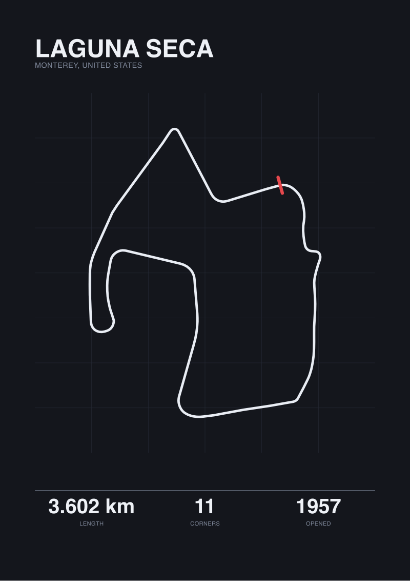 Laguna Seca
The print from this article · from €29.95
View the print →
Laguna Seca
The print from this article · from €29.95
View the print →
The Real Cost
We usually use a section like this to put a figure on what a comparison gets wrong. This piece is not a comparison. The cost here is different, and it is worth naming.
The cost of leading with the elevation figure — as almost every article on this corner does — is that it teaches the reader the wrong thing. It suggests the Corkscrew is hard because it goes down a lot. It is not. It is hard because you have to commit to a direction change before your eyes can see where you are going, and the descending gradient removes the last cue you had left. Downhill is the amplifier. It is not the mechanism.
Frame the cost in metres of margin instead of metres of drop. The reason drivers get the Corkscrew wrong is that the correct line uses inside kerb on both direction changes and the room on the outside of the second one is short. There are metres — very few of them — between a correctly held exit and a lost car. That is where the price is paid. Not in a figure that describes the topography, but in the geometry of what happens when the second apex is missed by a car's width.
This is what we mean when we say the studio traces before it draws. When we prepare a print of Laguna Seca for the shop at /shop/, we produce it from a 2D polyline that is accurate to within a metre of the published length. We do not draw the elevation. The print is a plan view — and anyone who has driven the corner knows the plan view is not the whole story, but they also know it tells you where the direction change happens and how tight the exit is, and those two facts explain more of the corner than any elevation quote in circulation.
If You Only Remember One Thing
The elevation drop of the Corkscrew is a spectator statistic. It is quoted often, verified rarely, and easy to disagree with once you look at the sources side by side. We do not publish it because we cannot defend it from our own data.
The geometry, on the other hand, is exactly what our trace of Laguna Seca shows: a blind entry into a full direction reversal on a short section of a 3.601-kilometre lap. That is the reason the corner is hard. If you want the drop, source a topographic survey. If you want the racing, read the map — and the next question, which is where the real work starts, is why almost no other circuit in the world reproduces this particular combination of blind crest and reversal on any comparable stretch of tarmac.
FAQ
Why does this article refuse to state the Corkscrew's elevation drop in metres?
Because our grounding data is a two-dimensional trace of the circuit taken from the OpenStreetMap raceway layer under ODbL. It gives us horizontal length — 3.601 kilometres, within a metre of the published 3.602 — but it contains no elevation vector. Any drop figure we published would have to be sourced from a third party we have not verified against the same geometry. Our editorial rule is that we do not repeat measurements we cannot defend from our own working data.
What is the actual length of Laguna Seca, then?
There are two numbers worth carrying. The published length is 3.602 kilometres. Our own trace of the same circuit, walked around the OpenStreetMap raceway polyline, comes to 3.601 kilometres. The one-metre gap is well within the rounding tolerance you would expect between a homologation figure and a map-traced measurement, and we treat the two as effectively in agreement rather than as a discrepancy worth resolving.
If not the elevation, what makes the Corkscrew difficult?
The plan-view geometry alone explains most of it. The corner enters over a blind crest, then reverses the driver's bearing through two quick direction changes on a short section of tarmac. You cannot see the second apex from the braking zone, and the outside of the second change has limited margin. The downhill gradient is real, and it amplifies the difficulty, but it is not the mechanism — the mechanism is committing to a direction change before your eyes catch up with the road.
Is the Corkscrew's difficulty exaggerated by fans?
Not in our reading. The difficulty is legitimate, but it is usually described using the wrong variable. Elevation drop is the number that gets quoted; direction reversal on a blind entry is the fact that actually explains the corner. Both are true. Only one of them is the reason the corner is famous among drivers as opposed to famous among photographers, and they are not the same reason at all.
Why do published Corkscrew elevation figures disagree with each other?
Because the corner does not have a single defensible measurement. Depending on where the top and bottom points are placed — braking zone crest, first apex, second apex, exit kerb — the answer changes by tens of feet. There is no homologation figure for a corner-internal drop the way there is for total circuit length. That is why we treat every figure in general circulation as unverified until a stated baseline is attached to it.
Does the OpenStreetMap raceway layer include elevation data?
Not in the form we can use for editorial claims. The raceway polyline is a horizontal geometry under the ODbL licence, and while elevation data does exist elsewhere in the wider OSM ecosystem, it is not part of the raceway layer we traced. A defensible elevation claim would need a separate topographic survey aligned to the same polyline, and that is not what we have in front of us for this article.
What should I read next if I want to understand the corner from a driver's perspective?
The productive next step is a proper topographic survey aligned to the racing line — that is where the elevation figure comes from when it comes from anywhere real. After that, in-car footage from a driver you trust, watched frame by frame through the direction reversal rather than at full speed. Neither of those is our department. Our department is the plan view, and this article is what we have to say from inside it.
From the collection
New circuits and 10% off your first print.
One email now with your code. No noise after.