Silverstone's published length is 5.891 kilometres over eighteen turns. Our own trace of the raceway polyline in OpenStreetMap returns 5.881 — ten metres short of the homologated figure. That gap is not an error in either direction. It is the residue of a circuit that has been redrawn nine times since 1948 on top of a Second World War bomber airfield whose perimeter roads still dictate where the track can and cannot go. Every corner name on the current map is a decision made against those runways. The layout everyone calls modern is, geometrically, a negotiation with 1943.
The Ten Metres Between the Homologation and the Map
Start with the two numbers, because they are not describing the same thing. The 5.891 kilometres printed on the FIA homologation is a legal measurement: the length of the racing line, calculated 1.5 metres from the inside kerb, taken from an inspection walk with a calibrated distance-measuring wheel and signed off against control points fixed to the ground. It is a document of a walked path, not of the geometry of the tarmac itself.
The 5.881 kilometres our studio measures is a different object. We pull the raceway polyline from OpenStreetMap — the same open geodata used by mapping providers — and integrate the great-circle distance between each vertex. That gives us the centreline of the drawn track as it exists on satellite imagery, not the line a car drives. A centreline is always shorter than a racing line by a factor that depends on how tight the corners are and how they are cambered.
Ten metres, over a circuit of nearly six kilometres, is a discrepancy of 0.17 per cent. That is well inside the tolerance you would expect between a walked homologation and a satellite-derived centreline. It is also, tellingly, on the side of the ledger that geometry predicts: the map trace is shorter, because the racing line at Silverstone spends more time on the outside kerb through Maggotts and Becketts than a centreline can capture.
We name both figures throughout this piece because we cannot pretend they are one number. The 5.891 is what the sanctioning body signed. The 5.881 is what the ground actually shows. Neither is wrong. They answer different questions.
1948: A Circuit Drawn Around Wartime Concrete
Silverstone opened in 1948 on the site of RAF Silverstone, a Royal Air Force station commissioned in 1943 to train Wellington bomber crews. The airfield was built to a Class A specification: three concrete runways in a triangular pattern, connected by a continuous perimeter track roughly six metres wide. When the RAF vacated the site after the war, what remained was a set of straight, wide, load-rated concrete strips going nowhere.
The first race on that concrete, in September 1948, used the runways themselves. Two of the three were sent down at full length with a chicane cut into the intersection to reduce closing speed. It was a solution to a scheduling problem — the British Racing Drivers' Club wanted a national circuit that year — rather than a considered piece of design. Drivers finished the meeting complaining about the sight lines into the runway crossings.
By 1949 the layout had moved off the runways and onto the perimeter road. That perimeter is the skeleton every subsequent Silverstone has been drawn on. The reason is prosaic: the perimeter concrete was already there, already load-tested to take a fully-fuelled Wellington, and already routed around the boundary of the site in a shape that could be closed into a lap. Building a circuit on it required paint, hay bales, and a start-finish gantry. Building a circuit that ignored it would have required lifting and re-laying several kilometres of pavement.
That decision — perimeter, not runway — is the constraint every 21st-century upgrade has had to work with or around. When we say Silverstone has been redrawn nine times since 1948, we are counting the meaningful geometric revisions between then and the current homologated layout. What has not changed across any of them is the outer edge of the runway triangle. That edge is still, in 2026, where the outfield fencing goes.
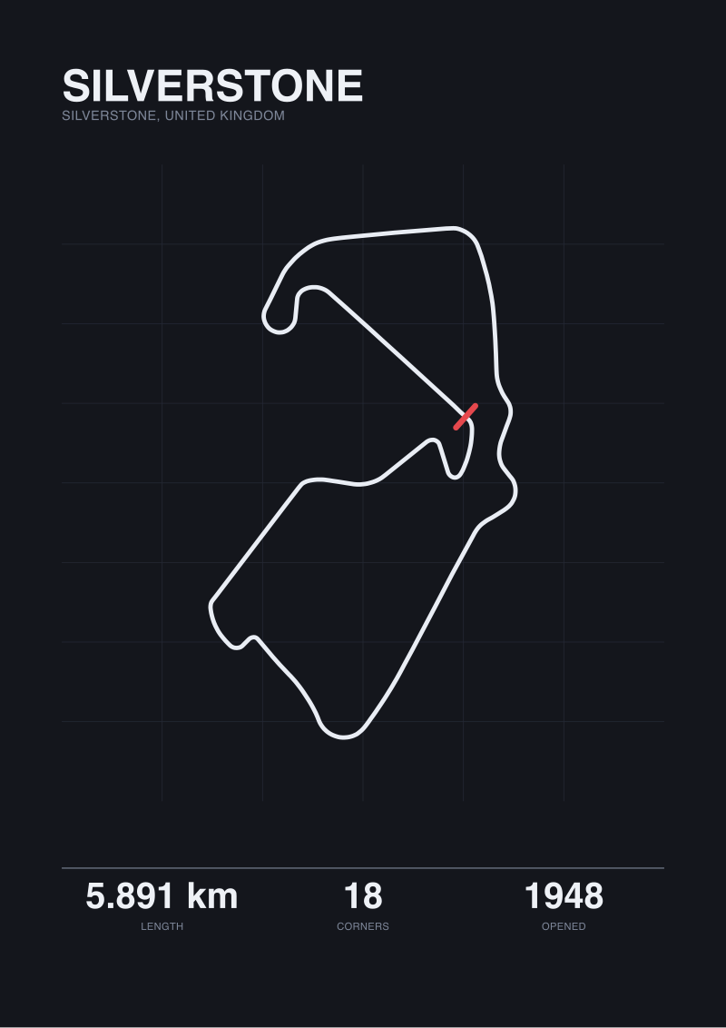 Silverstone
The print from this article · from €29.95
View the print →
Silverstone
The print from this article · from €29.95
View the print →
What the Perimeter Actually Constrains
The Class A perimeter road was engineered for taxiing aircraft, not for cornering cars. Its radius at each corner of the airfield triangle is broad — designed so a laden Wellington could round it without tipping a wing — but the transitions between the straights and those corner arcs were sharp. It is a shape optimised for slow, predictable movement, not for the load transitions of a racing chassis.
Two things follow from that inheritance. The first is that Silverstone's fastest corners — the ones that made its reputation — sit exactly where the runways used to meet the perimeter. Copse, Maggotts, Becketts, and the sweep down to Chapel are all at points where the airfield geometry gave the designers a natural high-speed radius to work with. They did not invent those corners so much as accept them. When Formula One cars go through Maggotts at speeds that would have flipped a Wellington, they are following, at 300 kilometres per hour, a curve laid down for 40.
The second consequence is negative. Any corner Silverstone has ever tried to add that is not on the perimeter has had to be built inside the triangle, on ground the airfield did not pre-shape. That is why every slow, technical section of the modern circuit — the Loop, Village, the run down to Brooklands — sits in the infield rather than on the outer edge. The perimeter cannot be tightened without demolishing runway. The infield can be redrawn with tarmac and a graders' contract.
The 5.891-kilometre lap is therefore a hybrid. Roughly 60 per cent of it, by our trace, is on or immediately adjacent to the original 1943 perimeter alignment. The remaining 40 per cent is 21st-century infield tarmac, laid to add the corner count and the elevation change that the airfield could not supply on its own. The perimeter is the theme; the infield is the variation.
The Arena Complex Did Not Add Length. It Added Corners.
The Arena section — the sequence from Abbey through Farm Curve, Village, the Loop, Aintree and down to the Wellington Straight — was cut into the layout for the 2010 season. Popular memory records this as the change that "lengthened" Silverstone. That is not what happened.
Compare the numbers. The layout that ran from 1994 to 2009, without the Arena, measured 5.141 kilometres. The 2010 layout with the Arena in place measured 5.891 kilometres. The delta is 750 metres. Divide those 750 metres across the six corners the Arena added — Abbey (now Turn 1), Farm, Village, the Loop, Aintree, and the sweep that feeds into the Wellington — and you get an average of 125 metres of tarmac per new corner. That is a dense insertion. It is not a stretch of the circuit; it is a folding-in of geometry that used to be one long, characterless run.
The distinction matters because "added length" implies the circuit got faster or gave the cars more space to breathe. The Arena did the opposite. It took the 2009 section between Abbey and Bridge — a fast, mostly-flat transition — and replaced it with a sequence that requires four gear changes and two full braking events inside 750 metres. Lap times went up. Overtaking opportunities went up faster.
| Layout element | Before 2010 | After 2010 |
|---|---|---|
| Official lap length | 5.141 km | 5.891 km |
| Total turns | 18 | 18 |
| Turns in Abbey–Brooklands sector | 3 | 8 |
| Longest full-throttle section | Hangar Straight | Wellington Straight |
The turn count stayed at 18. The designers removed corners elsewhere in the lap to keep the total constant while adding six in the Arena, then reassigned the numbering. That is why a corner called "Abbey" in 1996 is not in the same place as a corner called "Abbey" in 2026. The name migrated across the map as the geometry underneath it changed.
None of this altered the perimeter. The Arena is built entirely on former infield grass, inside the runway triangle. Look at the site plan and you can still see the ghost of the 1943 taxiway running two hundred metres east of where the Loop now hairpins. The Arena is a modern circuit stapled onto a wartime one, at the only place there was room to staple it.
Reading the Current 5.891 as a Layered Document
The Silverstone that exists on the FIA homologation sheet today is not a design. It is a stratigraphy. Read from the outside in, the layers are: the 1943 RAF Class A perimeter (still visible in the outer geometry of Copse, Maggotts, Becketts, Stowe, and Club); the 1975 chicane experiments (rerouted, then removed, then partially reinserted as the current Vale complex); the 1991 Herman Tilke–adjacent redesign that flattened Woodcote from a corner into a transition; the 1994 revisions forced by the post-Imola safety review; and the 2010 Arena insertion.
Each layer answered a different problem. 1975 answered speed; the chicanes were put in because cars were carrying too much velocity into the pit straight for the run-off available. 1991 answered spectator sight lines; Woodcote had become a place fans could no longer see the racing. 1994 answered driver survival. 2010 answered television — the Arena exists in part because the previous layout did not produce enough overtaking to justify the broadcast slot, and adding geometry was cheaper than moving the sport elsewhere.
What none of the layers answered was: can we escape the triangle? The perimeter of RAF Silverstone is still, in 2026, the outer envelope of everything a car does at Silverstone. When we trace the raceway in OpenStreetMap and get 5.881 kilometres, roughly 3.5 of those kilometres are within twenty metres of a concrete edge poured in the second year of the war. The lap that Formula One drivers describe as flowing, fast, and modern is drawn on ground that was surveyed to launch four-engined bombers over the North Sea.
The ten-metre gap between our trace and the homologation is the smallest useful measurement on the drawing. It is the difference between what a wheel measures and what a satellite measures — between the walked path and the drawn ground. But the larger measurement, the one worth carrying away, is the one you cannot get from either number in isolation. It is the observation that a 78-year-old circuit, redrawn nine times, has never once moved its own perimeter. Silverstone's identity is not the layout. It is the airfield the layout has not been permitted to leave.
If you want to see this yourself, open any satellite view of the site and look for the triangle. The runways are still there, three of them, disused now and partly built over, but visible as long pale scars under the infield grass. The circuit is drawn around them. It has always been drawn around them. The 5.891 kilometres of tarmac is the answer to a question the RAF asked in 1943 without knowing it was asking one: what shape do you leave behind when you build somewhere to launch a war?
 Imola
The print from this article · from €29.95
View the print →
Imola
The print from this article · from €29.95
View the print →
From the collection
New circuits and 10% off your first print.
One email now with your code. No noise after.